You are here: OGC Public Wiki>WCTileServiceSWG Web>AviationWeatherCubeUC (17 Jun 2015, clittle)Edit Attach
Aviation Weather Cube (IWXXM) Use Case
User Story
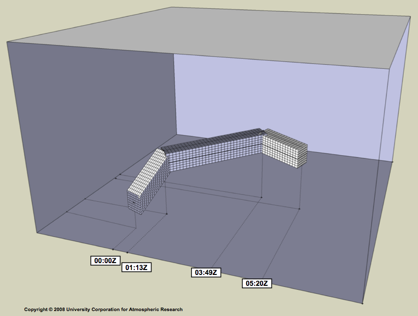
There is a concerted effort to improve the efficiency and capacity of future Air Traffic Management (ATM) around the globe, moving from the relatively fixed, slot-based, approach of managing airspace to a more flexible, trajectory based, weather sensitive approach. In Europe, there is the Single European Skies ATM research (SESAR) project, and in America, the NextGen initiative involving the "4D Weather Cube". The attached diagram was an early indication of an approach to sending data for a specific trajectory, but this is rather misleading. The diagram seems to imply that data would be re-projected onto different grids or coordinate reference systems for each phase of the flight, which would be expensive. A much more convincing approach would be to send data according to voxels with their axes aligned with large scale CRS, so that there is a 'jaggy' corridor of data cubes around the trajectory, looking as if it is made in MineCraft or Lego. This avoids re-projecting lots of data for every single aircraft or trajectory or corridor. E.g. voxel could be a WCTileS data-cube containing the relevant data, such as atmospheric wind speed and direction (for route optimisation), temperature and humidity (for fuel optimisation), and air turbulence (for safety). 'Later' cubes, towards the end of the trajectory, could be produced from separate, later forecasts or analyses, giving more accurate data than were available at the beginning of the flight. Many aircraft would share the same data cubes, which could be cached, e.g. in the satellite transmitting the data service, allowing reduced bandwidth.Actors
- Authorised server supplying data tiles covering Volume and Period Of Interest.
- One client aircraft, of many, receiving data tiles local to its trajectory of Points and Instants Of Interest.
- Internediate web caches to allow other clients to receive the same tiles if appropriate.
Preconditions
The server and client have negotiated a tile service for an Area, vertical extent and time duration Of Interest.Main Success Scenario
As the client aircraft moves in space and time, the client's local copies of data tiles are replaced and unneeded data tiles are deleted. The data tiles received allow the client to make informed decisions and alter course, speed and elevation. The data may include, but not be limited to, wind velocity, temperature, humidty (for engine efficiency control), Clear Air Turbulence indices, lightning risk, etc.Alternative Paths
- Client aircraft moves out of range, or out of time, of service and must negotiate a new service with another supplier for new Area Of Interest.
- The service enters backup mode and the client aircraft must negotiate the backup service with another supplier for the same Area Of Interest, but perhas with differnt characteristics.
- The offered service does not have data of the appropriate (high enough) resolution to enable sensible decisions.
- The client aircraft diverts to a backup trajectory and landing.
Postconditions
- The recently used/requested tiles remain in the client's local store for resilience.
- The time expired requested tiles may or may not remain in the client's local store.
- The recently used/requested tiles remain in the web cache, unless the service enforces no cacheing.
Requirements Issues/Discussion
- In international and national aviation, there are many safety critical issues with authorisation of services that should not be part of this service, but in a separate 'layer'.
- Aircraft have to plan emergency diversions, so there may be several trajectories being stored in one client.
- NextGen 4D Weather Cube trajectory:

| I | Attachment | Action | Size | Date | Who | Comment |
|---|---|---|---|---|---|---|
| |
Trajectory-4D.png | manage | 164 K | 19 May 2015 - 17:20 | UnknownUser | NextGen 4D Weather Cube trajectory |
Edit | Attach | Print version | History: r4 < r3 < r2 < r1 | Backlinks | View wiki text | Edit wiki text | More topic actions
Topic revision: r4 - 17 Jun 2015, clittle
-
 WCTileServiceSWG Web Toolbox
-
 Create New Topic
-
 Index
Index
-
 Search
-
 Changes
-
 Notifications
-
 RSS Feed
-
 Statistics
-
 Preferences
- Webs
-
 AIP8
AIP8
-
 ASTROdwg
-
 AgricultureSummit
-
 AustraliaNewZealandForum
-
 AviationDWG
-
 BigDataDwg
-
 BusinessValueCommittee
-
 CATdiscuss
-
 CDBswg
-
 CRSdefinitionResolver
-
 CRSdwg
-
 CanadaForum
-
 ChinaForum
-
 CitSciIE
-
 CitizenScienceDWG
-
 ClimateChallenge2009
-
 CoveragesDWG
-
 DiscreteGlobalGridSystemsDWG
-
 EMSpectrumDWG
-
 EMspectrumDWG
-
 ERGuidance
-
 EUforum
-
 EarthCube
-
 EnergyUtilitiesDwg
-
 GML
GML
-
 GeoSciMLswg
-
 GeoScienceDWG
-
 GeocodingAdHoc
-
 Geospatial3DMS
-
 HealthDWG
-
 HydrologyDWG
-
 I15swg
-
 ILAFpublic
-
 ISGdwg
-
 Ideas4OGC
-
 JAG
JAG
-
 JSONsubGroup
-
 JapanAssistance
-
 LandAdminDWG
-
 MLSdwg
-
 Main
Main
-
 MarineDWG
-
 MassMarket
-
 MetOceanDWG
-
 NREwg
NREwg
-
 NetCDFu
-
 NordicForum
-
 OGC
OGC
-
 PointCloudDWG
-
 QualityOfService
-
 SWEProCitSci
-
 Sandbox
-
 SmartCitiesDWG
-
 System
-
 TemporalDWG
-
 UKIAP2013
-
 UrbanPlanningDWG
-
 Vocabulary
-
 WCTileServiceSWG
-
 WPS
WPS
-
 WaterML
 The information you supply is used for OGC purposes only. We will never pass your contact details to any third party without your prior consent.
 If you enter content here you are agreeing to the OGC privacy policy.
Copyright &© by the contributing authors. All material on this collaboration platform is the property of the contributing authors.
Ideas, requests, problems regarding OGC Public Wiki? Send feedback


