You are here: OGC Public Wiki>MetOceanDWG Web>MetOceanUseCases>CaliforniaFireCase (14 Sep 2010, JohnSchattel)Edit Attach
The drought in the western third of the United States has worsened over the first 10 years of the new millennium. The historical fire season (June – September) has expanded to all months of the calendar for the state of California. Firefighting cost/loss models indicate that a 1% reduction in deployment time can yield approximately $10 Million in savings. So anticipating fire behavior is critical. The current situation has firefighting resources stretched thin between wildfires east of the San Diego metro area and a forecast fire in the Sierra-Nevada Mountains along the western shore of Lake Tahoe. The National Oceanic Atmospheric Administration (NOAA) Incident Meteorologist (IMET), stationed at a command center with access to cellular communications, is retrieving and analyzing satellite and radar image animations, surface observations from a mesonet database, and Short Range Ensemble Forecast (SREF) wind direction probability curves. He uses these data to assist the Incident Command (IC) with decisions on where to deploy firefighting personnel.
The SREF forecast distribution indicates a 70% chance of continued northerly winds over the next 24 hours which argues for stationing fire line crews ahead of the currently advancing fires. However, the IMET noticed a secondary maximum in the SREF curve indicating a 20% chance of a wind shift that would send embers to a densely populated section of the Lake Tahoe shoreline. Based on the IMET’s assessment, the IC contacts a Nevada official, forwarding the SREF forecast data to her, and recommending she pre-deploy firefighters to respond to any shift in the winds. Later in the day, satellite and radar images, downloaded from NOAA online services to the cell phone of a fire crew leader on the east side of Lake Tahoe, clearly show the development of diurnal thunderstorms which indeed do cause a westerly shift in winds. However, because of the pre-deployment of fire assets, the ember induced fires were quickly extinguished and the eastern side of the lake was spared any damage.
Radar WMS:
http://gis.srh.noaa.gov/arcgis/services/RIDGERadar/MapServer/WMSServer?request=GetCapabilities&service=WMS
Satellite Web Page:
http://www.goes.noaa.gov/GSSLOOPS/wcir.html
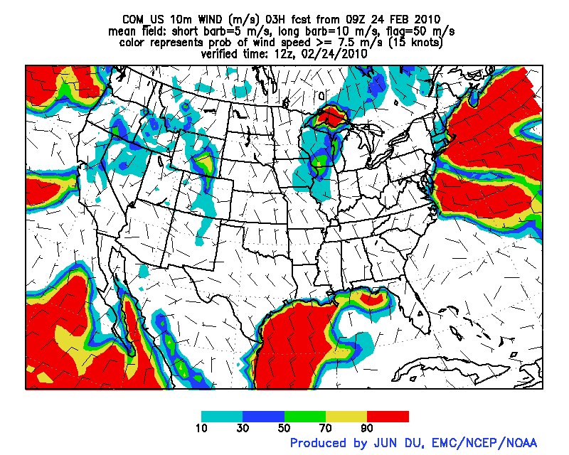
SREF Probability of Winds > 15 kts (Not the probability curve discussed above)
http://www.emc.ncep.noaa.gov/mmb/SREF/FCST/COM_US/web_js/html/prob_w10m.html
Mesonet Data for Lake Tahoe
http://www.wrh.noaa.gov/mesowest/mwmap.php?map=renos
 -- JohnSchattel - 09 Feb 2010
http://gis.srh.noaa.gov/arcgis/services/RIDGERadar/MapServer/WMSServer?request=GetCapabilities&service=WMS
Satellite Web Page:
http://www.goes.noaa.gov/GSSLOOPS/wcir.html
SREF Probability of Winds > 15 kts (Not the probability curve discussed above)
http://www.emc.ncep.noaa.gov/mmb/SREF/FCST/COM_US/web_js/html/prob_w10m.html
Mesonet Data for Lake Tahoe
http://www.wrh.noaa.gov/mesowest/mwmap.php?map=renos
- SREF Model Probability of Winds > 15 kts:

| I | Attachment | Action | Size | Date | Who | Comment |
|---|---|---|---|---|---|---|
| |
SREFw10prb1_03.gif | manage | 96 K | 24 Feb 2010 - 21:14 | JohnSchattel | SREF Model Probability of Winds > 15 kts |
Edit | Attach | Print version | History: r5 < r4 < r3 < r2 | Backlinks | View wiki text | Edit wiki text | More topic actions
Topic revision: r5 - 14 Sep 2010, JohnSchattel
- Webs
-
 AIP8
AIP8
-
 ASTROdwg
-
 AgricultureSummit
-
 AustraliaNewZealandForum
-
 AviationDWG
-
 BigDataDwg
-
 BusinessValueCommittee
-
 CATdiscuss
-
 CDBswg
-
 CRSdefinitionResolver
-
 CRSdwg
-
 CanadaForum
-
 ChinaForum
-
 CitSciIE
-
 CitizenScienceDWG
-
 ClimateChallenge2009
-
 CoveragesDWG
-
 DiscreteGlobalGridSystemsDWG
-
 EMSpectrumDWG
-
 EMspectrumDWG
-
 ERGuidance
-
 EUforum
-
 EarthCube
-
 EnergyUtilitiesDwg
-
 GML
GML
-
 GeoSciMLswg
-
 GeoScienceDWG
-
 GeocodingAdHoc
-
 Geospatial3DMS
-
 HealthDWG
-
 HydrologyDWG
-
 I15swg
-
 ILAFpublic
-
 ISGdwg
-
 Ideas4OGC
-
 JAG
JAG
-
 JSONsubGroup
-
 JapanAssistance
-
 LandAdminDWG
-
 MLSdwg
-
 Main
Main
-
 MarineDWG
-
 MassMarket
-
 MetOceanDWG
-
 NREwg
NREwg
-
 NetCDFu
-
 NordicForum
-
 OGC
OGC
-
 PointCloudDWG
-
 QualityOfService
-
 SWEProCitSci
-
 Sandbox
-
 SmartCitiesDWG
-
 System
-
 TemporalDWG
-
 UKIAP2013
-
 UrbanPlanningDWG
-
 Vocabulary
-
 WCTileServiceSWG
-
 WPS
WPS
-
 WaterML
 The information you supply is used for OGC purposes only. We will never pass your contact details to any third party without your prior consent.
 If you enter content here you are agreeing to the OGC privacy policy.
Copyright &© by the contributing authors. All material on this collaboration platform is the property of the contributing authors.
Ideas, requests, problems regarding OGC Public Wiki? Send feedback


