 |
|
| NOTICE: The HydrologyDWG OGC Public Wiki has been moved to https://github.com/opengeospatial/hydro-dwg-wiki . |
NOTICE: The HydrologyDWG OGC Public Wiki has been moved to https://github.com/opengeospatial/hydro-dwg-wiki .
You are here: OGC Public Wiki>HydrologyDWG Web>WaterML2Part2>ApplicationProgrammingInterfaceDevelopment>RgsVocabularies (17 Mar 2014, PeterTaylor)Edit Attach
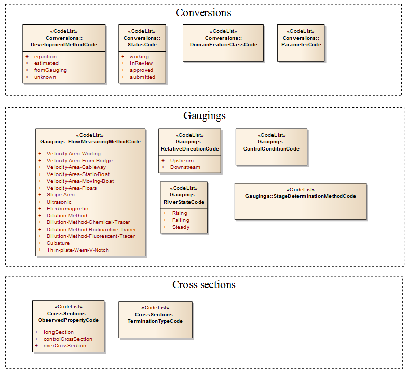
The page is broken up into parts reflecting vocabularies from the various parts of the model, along the lines of the following diagram.
The question for the RGS group is: we can also support internal codes by encodings just using the internal vocabulary, but it is desirable to have some common terms. Do we want to define the ones below for use in standard? The main references below are from USGS codes as they tend to have fairly comprehensive codes with decent web availability. We really need input from you guys (the experts!) on these. If you have other vocabularies that can be used in harmonisation, please drop them here or link to them.
 Methodology for developing vocabs
There is a simple workflow from here (http://www.asis.org/Bulletin/Dec-12/DecJan13_Zaharee.html) showing a process for developing a vocab/CV.
Methodology for developing vocabs
There is a simple workflow from here (http://www.asis.org/Bulletin/Dec-12/DecJan13_Zaharee.html) showing a process for developing a vocab/CV.
 Gives a basic view of how things generally proceed..
Most of these map to the ISO ones; however the ISO one is missing ice.
-- PeterTaylor - 14 Mar 2014
Methodology for developing vocabs
There is a simple workflow from here (http://www.asis.org/Bulletin/Dec-12/DecJan13_Zaharee.html) showing a process for developing a vocab/CV.
Gives a basic view of how things generally proceed..
Conversion/Ratings
Development method code
Specifies the method used for developing the rating curve.| Term | Definition | Reference(s) |
|---|---|---|
| Equation | Rating was developed using a theoretical equation. | |
| Estimated | Rating share was estimated in some way. | |
| fromGauging | Rating was developed using a collection of discrete gauging observations | |
| unknown | Development method is not known. |
Status codes
| Term | Definition | Reference(s) |
|---|---|---|
| Working | The rating is the current working version | |
| InReview | The rating is under review. | |
| Approved | The rating has been approved for use. | |
| Submitted | The rating has been submitted for review |
Domain feature class
From the HY_features feature types we get a good top-level feature vocabulary:- / HY_Basin
- / HY_BasinAggregate
- / HY_Catchment
- / HY_CatchmentArea
- / HY_CatchmentBoundary
- / HY_CatchmentRepresentation
- / HY_CrossSection
- / HY_DistanceToRefPoint
- / HY_FlowPath
- / HY_Glacier
- / HY_HydroFeature
- / HY_HydroFeatureName
- / HY_HydrographicNetwork
- / HY_IndirectPosition
- / HY_LongitudinalSection
- / HY_MileageSystemAxis
- / HY_Network
- / HY_Outfall
- / HY_ReferencePoint
- / HY_RelativePosition
- / HY_Reservoir
- / HY_RiverMileageCS
- / HY_WaterBody
- / HY_WaterBodySegment
- / HY_WaterBodyStratum
- / HY_Water_LiquidPhase
- / HY_Water_SolidPhase
- / HY_Watershed
Gaugings
Flow measurement method
I've created a vocab for this based on the ISO measurement of flow in open channels (the terms are shown in above diagram). USGS also has the following: http://help.waterdata.usgs.gov/code/meas_type_query?fmt=html| Q Meas Type Cd | Q Meas Type Nm | Q Meas Type Ds |
|---|---|---|
| UNSP | Unspecified | Discharge measurement made by an unspecified method |
| WADE | Wading | Discharge measurement made by wading into the water. |
| BRUS | Bridge upstream side | Discharge measurement made from a bridge on the upstream side. |
| BRDS | Bridge downstream side | Discharge measurement made from a bridge on the downstream side. |
| CWAY | Cableway | Discharge measurement made from cableway. |
| ICE | Ice | Discharge measurement made through river ice. |
| MBOT | Manned moving boat | Discharge measurement made from a moving manned boat. |
| SBOT | Stationary boat | Discharge measurement made from a stationary manned boat. |
| RC | Remote control boat | Discharge measurement using a remote control boat. |
| OTHR | Other | Discharge measurement was made by other means. |
| BOAT | Boat | Discharge measurement was made from a boat (only used for tranfer not user-selectable). |
| CRAN | Bridge (crane) | Discharge measurement was made using a bridge crane (only used for tranfer not user-selectable). |
Relative direction
We currently only two showing, but USGS has following (from http://help.waterdata.usgs.gov/code/chan_location_query?fmt=html):| Gage Rel Loc Cd | Gage Rel Loc Nm | Gage Rel Loc Ds |
|---|---|---|
| UNSP | Unspecified | The relative location of the measurement section was not specified by user. |
| ATGA | At the gage | The measurement section was at the gage. |
| UPST | Upstream | The measurement section was upstream from the gage |
| DNST | Downstream | The measurement section was downstream from the gag |
Control conditions
USGS codes (http://help.waterdata.usgs.gov/codes-and-parameters/rating-control-condition-code-control_type_cd):UNSP The stream control conditions were not specified. AICE The stream control is covered with anchor ice. CICE The stream control was convered by ice. CLER The stream control was clear of any obstructions. FILL The stream control was filled. HVDB The stream control was heavily covered with debris. LGDB The stream control was lightly covered with debris. ALGA The stream control was covered with moss/algae. MAHV The stream control was heavily covered with moss/algae. MALT The stream control was lightly covered with moss/algae. MAMD The stream control was moderately covered with moss/algae. MDDB The stream control was moderately covered with debris. NFLW There was no flow over the stream control. SCUR The stream control has scour conditions. SICE The stream control has shore ice. SUBM The stream control was submerged.
Stage determination method
Straight from USGS (http://help.waterdata.usgs.gov/codes-and-parameters/water-level-method-codes-siwlmt.edi)--------------------------------- Code Description --------------------------------- A Airline Airline measurement. B Analog Analog or graphic recorder. C Calib. airline Calibrated airline measurement. E Estimated Estimated. F Transducer Transducer. G Pressure-gage Pressure-gage measurement. H Calib.Pres.Gage Calibrated pressure-gage measurement. L Geophysical log Interpreted from geophysical logs. M Manometer Manometer measurement. N Nonrec. gage Nonrecording gage. O Observed Observed. P Acoustic Pulse Acoustic Pulse measurement R Reported Reported, method not known. S Steel tape Steel-tape measurement. T Electric tape Electric-tape measurement. V Calib.Elec.Tape Calibrated electric-tape measurement. W Calib.Elec.Cable Calibrated electric cable. X Uncal.Elec.Cable Uncalibrated electric cable. Z Other Other.
Velocity method (not currently in the model)
We should probably add this to the gauging method metadata. From http://help.waterdata.usgs.gov/code/velocity_method_query?fmt=html:| Meth Cd | Meth Tp | Meth Nm | Meth Ds |
|---|---|---|---|
| SADVM | SWVL | Velocity, Sideways looking ADVM | Stream velocity measured using a sideways looking acoustic doppler velocity meter. |
| UADVM | SWVL | Velocity, Upward looking ADVM | Stream velocity measured using an upward looking acoustic doppler velocity meter. |
| V-EST | SWVL | Stream velocity, estimated | Stream velocity, estimated |
| VADCP | SWVL | Stream velocity, ADCP | Stream velocity, acoustic doppler current profiler |
| VADV | SWVL | Stream velocity, ADV | Stream velocity, acoustic doppler velocimeter |
| VELC | SWVL | Velocity,Electromagnetic Vel Mtr | Stream velocity measured using an Electromagnetic Velocity Meter |
| VICE | SWVL | Stream Velocity, Ice Vane Meter | Stream velocity measured with Ice Vane Meter |
| VIPAA | SWVL | Velocity, Polymer Cup AA Meter | Stream Velocity measured with a Price AA meter with polymer cups |
| VIPYG | SWVL | Velocity,Polymer Cup Pygmy Meter | Stream Velocity measured with a Price Pygmy meter with polymer cups |
| VOPT | SWVL | Stream velocity, optical current | Velocity measured by a surface velocity stroboscopic device |
| VOTT | SWVL | Stream velocity, horiz. shaft | Stream velocity, horizontal shaft (Ott) meter |
| VPAA | SWVL | Stream velocity, Price AA | Stream velocity, Price AA meter |
| VPYG | SWVL | Stream velocity, pygmy | Stream velocity, Price pygmy meter |
| VRAD | SWVL | Stream velocity, radar | Stream velocity, radar |
| VTIME | SWVL | Stream Velocity, Time of Travel | Stream velocity measured by any time of travel method |
| VTRNS | SWVL | NWIS 4.8 Transferred Velocity | The method used to measure the velocity is not known. |
| VULT | SWVL | Stream velocity, ultrasonic | Stream velocity, ultrasonic meter |
Water state
Straight from USGS (http://help.waterdata.usgs.gov/code/hydro_conditions_query?fmt=html)| Hyd Cond Cd | Hyd Cond Nm |
|---|---|
| 4 | Stable, low stage |
| 5 | Falling stage |
| 6 | Stable, high stage |
| 7 | Peak stage |
| 8 | Rising stage |
| 9 | Stable, normal stage |
| A | Not determined |
| X | Not applicable |
Quality
The quality codes could apply to the stage measurement, the discharge measurement or an overall 'gauging quality'. This needs discussion. We also have the generic waterml2 part 1 codes: http://www.opengis.net/def/waterml/2.0/quality/Discharge quality
| Term | Definition | Reference(s) |
|---|---|---|
| Excellent | The data is within 2% (percent) of the actual flow | http://help.waterdata.usgs.gov/codes-and-parameters/discharge-measurement-quality-code |
| Good | The data is within 5% (percent) of the actual flow | http://help.waterdata.usgs.gov/codes-and-parameters/discharge-measurement-quality-code |
| Fair | The data is within 8% (percent) of the actual flow | http://help.waterdata.usgs.gov/codes-and-parameters/discharge-measurement-quality-code |
| Poor | The data is within >8% (percent) of the actual flow | http://help.waterdata.usgs.gov/codes-and-parameters/discharge-measurement-quality-code |
Cross-sections
TODO-- PeterTaylor - 14 Mar 2014


| I | Attachment | Action | Size | Date | Who | Comment |
|---|---|---|---|---|---|---|
| |
Capture.PNG | manage | 52 K | 14 Mar 2014 - 02:59 | PeterTaylor |
Edit | Attach | Print version | History: r2 < r1 | Backlinks | View wiki text | Edit wiki text | More topic actions
Topic revision: r2 - 17 Mar 2014, PeterTaylor
- Webs
-
 AIP8
AIP8
- ASTROdwg
- AgricultureSummit
- AustraliaNewZealandForum
- AviationDWG
- BigDataDwg
- BusinessValueCommittee
- CATdiscuss
- CDBswg
- CRSdefinitionResolver
- CRSdwg
- CanadaForum
- ChinaForum
- CitSciIE
- CitizenScienceDWG
- ClimateChallenge2009
- CoveragesDWG
- DiscreteGlobalGridSystemsDWG
- EMSpectrumDWG
- EMspectrumDWG
- ERGuidance
- EUforum
- EarthCube
- EnergyUtilitiesDwg
- GML
- GeoSciMLswg
- GeoScienceDWG
- GeocodingAdHoc
- Geospatial3DMS
- HealthDWG
- HydrologyDWG
- I15swg
- ILAFpublic
- ISGdwg
- Ideas4OGC
- JAG
- JSONsubGroup
- JapanAssistance
- LandAdminDWG
- MLSdwg
- Main
- MarineDWG
- MassMarket
- MetOceanDWG
- NREwg
- NetCDFu
- NordicForum
- OGC
- PointCloudDWG
- QualityOfService
- SWEProCitSci
- Sandbox
- SmartCitiesDWG
- System
- TemporalDWG
- UKIAP2013
- UrbanPlanningDWG
- Vocabulary
- WCTileServiceSWG
- WPS
- WaterML
If you enter content here you are agreeing to the OGC privacy policy.
Copyright &© by the contributing authors. All material on this collaboration platform is the property of the contributing authors.
Ideas, requests, problems regarding OGC Public Wiki? Send feedback