 |
|
| NOTICE: The HydrologyDWG OGC Public Wiki has been moved to https://github.com/opengeospatial/hydro-dwg-wiki . |
NOTICE: The HydrologyDWG OGC Public Wiki has been moved to https://github.com/opengeospatial/hydro-dwg-wiki .
You are here: OGC Public Wiki>HydrologyDWG Web>GroundwaterInteroperabilityExperiment2>29Oct2014--GW2IEMeeting26>GwmlDistributedValues (08 Dec 2014, EricBoisvert)Edit Attach
There are various way we can report a collection of values organised spatially (eg, distributed over an aquifer). Since we use O&M to represent most of our values, we can use om:parameter to attach a location to the observation and repeat as many observations as we need :
example of one of the observation
 The following example is a stripped down version, just showing how Observation, SF_SpatialSamplingFeature and a GW_AquiferSystem are articulated.
<?xml version="1.0" encoding="UTF-8"?>
<om:OM_Observation gml:id="ab.ww.402557.flow.1"
   xsi:schemaLocation="http://www.opengis.net/om/2.0 http://schemas.opengis.net/om/2.0/observation.xsd"
   xmlns:gml="http://www.opengis.net/gml/3.2" xmlns:xlink="http://www.w3.org/1999/xlink"
   xmlns:swe="http://www.opengis.net/swe/2.0" xmlns:cv="http://www.opengis.net/cv/0.2/gml32"
   xmlns:om="http://www.opengis.net/om/2.0" xmlns:spec="http://www.opengis.net/samplingSpecimen/2.0"
   xmlns:xsi="http://www.w3.org/2001/XMLSchema-instance">
   <gml:description>Flow measurement in a single Observation with a location in om:parameter</gml:description>
   <om:phenomenonTime>
      <gml:TimeInstant gml:id="ab.ww.402557.flow.1.pt">
         <gml:timePosition>2012-05-01</gml:timePosition>
      </gml:TimeInstant>
   </om:phenomenonTime>
   <om:resultTime>
      <gml:TimeInstant gml:id="ab.ww.402557.flow.1.ti">
         <gml:timePosition>2012-05-01</gml:timePosition>
      </gml:TimeInstant>
   </om:resultTime>
   <om:procedure xlink:href="http://www.opengis.net/def/gwml/procedure/flowmeter"
      xlink:title="flow meter" />
   <!-- based on SOS 2.0 http://www.opengis.net/spec/SOS/2.0/req/spatialFilteringProfile -->
   <om:parameter>
      <om:NamedValue>
         <om:name
            xlink:href="http://www.opengis.net/def/param-name/OGCOM/
2.0/samplingGeometry" />
         <om:value>
            <gml:Point gml:id="SamplingPoint">
               <gml:pos srsName="urn:ogc:def:crs:EPSG::4326">52.9 7.52</gml:pos>
            </gml:Point>
         </om:value>
      </om:NamedValue>
   </om:parameter>
   <om:observedProperty
      xlink:href="http://www.opengis.net/def/gwml/phenomenon/flowspeed"
      xlink:title="groundwater flow speed" />
   <!--/req/gwml2-well/waterwell_observation_foi -->
   <om:featureOfInterest xlink:href="#ab.ww.402557"
      xlink:title="ab.ww.402557" />
   <om:result xsi:type="gml:MeasureType" uom="m/s">0.0021</om:result>
</om:OM_Observation>
The other way is to use gml:Coverage and use a single observation that reports all the values into a single result (this is essentially what WaterML does, but values are distributed temporally instead of spatially). This example reports 3 values (you would need to replicate the observation example above 3 times to reproduce this example below). This example uses a subtype of Coverage called MultiPointCoverage.
I think the om:parameter value is unnecessary (mistakenly left after a copy and paste perhaps?) as the geometry is provided by om:result. The WaterML example (http://www.waterml2.org/) doesn't use om:parameter.Note also that rather than structuring the result as <domainSet> and <rangeSet>, these can be delivered as location:value pairs.
-- BruceSimons - 08 Dec 2014
Yes - it was a copy-paste mistake. fixed
-- EricBoisvert - 08 Dec 2014
<?xml version="1.0" encoding="UTF-8"?>
<om:OM_Observation gml:id="ab.ww.402557.flow.1"
   xsi:schemaLocation="http://www.opengis.net/om/2.0 http://schemas.opengis.net/om/2.0/observation.xsd"
   xmlns:gml="http://www.opengis.net/gml/3.2" xmlns:xlink="http://www.w3.org/1999/xlink"
   xmlns:swe="http://www.opengis.net/swe/2.0" xmlns:cv="http://www.opengis.net/cv/0.2/gml32"
   xmlns:om="http://www.opengis.net/om/2.0" xmlns:spec="http://www.opengis.net/samplingSpecimen/2.0"
   xmlns:xsi="http://www.w3.org/2001/XMLSchema-instance">
   <gml:description>Flow measurement in a single Observation with a location in om:parameter</gml:description>
   <om:phenomenonTime>
      <gml:TimeInstant gml:id="ab.ww.402557.flow.1.pt">
         <gml:timePosition>2012-05-01</gml:timePosition>
      </gml:TimeInstant>
   </om:phenomenonTime>
   <om:resultTime>
      <gml:TimeInstant gml:id="ab.ww.402557.flow.1.ti">
         <gml:timePosition>2012-05-01</gml:timePosition>
      </gml:TimeInstant>
   </om:resultTime>
   <om:procedure xlink:href="http://www.opengis.net/def/gwml/procedure/flowmeter"
      xlink:title="flow meter" />
   <om:observedProperty
      xlink:href="http://www.opengis.net/def/gwml/phenomenon/flowspeed"
      xlink:title="groundwater flow speed" />
   <!--/req/gwml2-well/waterwell_observation_foi -->
   <om:featureOfInterest xlink:href="#ab.ww.402557"
      xlink:title="ab.ww.402557" />
   <om:result>
      <gml:MultiPointCoverage gml:id="cov1">
         <gml:description>example of multipoint coverage of a series of flow
            values. Note that is only one possible encoding, another interesting
            way is to use NetCDF</gml:description>
         <gml:descriptionReference />
         <gml:identifier codeSpace="http://www.example.com/">string</gml:identifier>
         <gml:name>string</gml:name>
         <gml:boundedBy>
            <gml:Envelope>
               <gml:lowerCorner>51 -110</gml:lowerCorner>
               <gml:upperCorner>52 -109</gml:upperCorner>
            </gml:Envelope>
         </gml:boundedBy>
         <gml:domainSet>
            <gml:MultiGeometry gml:id="gid">
               <gml:description>geometries</gml:description>
               <gml:identifier codeSpace="http://www.example.com/">string</gml:identifier>
               <gml:name>string</gml:name>
               <gml:geometryMember>
                  <gml:Point gml:id="obs_p1">
                     <gml:pos srsName="urn:ogc:def:crs:EPSG::4326">109.5 51.45</gml:pos>
                  </gml:Point>
               </gml:geometryMember>
               <gml:geometryMember>
                  <gml:Point gml:id="obs_p2">
                     <gml:pos srsName="urn:ogc:def:crs:EPSG::4326">109.554 51.31</gml:pos>
                  </gml:Point>
               </gml:geometryMember>
               <gml:geometryMember>
                  <gml:Point gml:id="obs_p3">
                     <gml:pos srsName="urn:ogc:def:crs:EPSG::4326">109.04 51.97</gml:pos>
                  </gml:Point>
               </gml:geometryMember>
            </gml:MultiGeometry>
         </gml:domainSet>
         <gml:rangeSet>
            <gml:ValueArray gml:id="v1" uom="m/s">
               <gml:identifier codeSpace="http://www.example.com/">values</gml:identifier>
               <gml:name>values</gml:name>
               <gml:valueComponent>
                  <!-- at this point, values can be many things, including a reference
                     to a external file or a free text datablock -->
                  <gml:Quantity uom="m/s">0.0021</gml:Quantity>
                  <gml:Quantity uom="m/s">0.0109</gml:Quantity>
                  <gml:Quantity xsi:nil="true" nilReason="missing" />
               </gml:valueComponents>
            </gml:ValueArray>
         </gml:rangeSet>
         <!-- no coverage function, therefore assume that there is a 1:1 between
            domain elements and range elements -->
      </gml:MultiPointCoverage>
   </om:result>
</om:OM_Observation>
To add more values, just add elements , just add geometryMembers and gml:Quantity.
-- EricBoisvert - 28 Oct 2014
Note: There are many variations and encoding for Coverage. For instance, we can also use the "interleave pattern", that encodes the coverage as a collection of geometry-values pairs instead of grouping all the geometries in a single block and then all the results into another block.
Standard Coverage
- Coverage
- All geometries
- All values
- mapping (when there is a 1:1 mapping between geometries and values, it is not required)
Interleaved Coverage
- DiscreetCoverage
- member
- geometry
- value
- member
<cv:CV_DiscreteCoverage gml:id="dc1"
xmlns:cv="http://www.opengis.net/cv/0.0"
xmlns:xsi="http://www.w3.org/2001/XMLSchema-instance"
xmlns:xlink="http://www.w3.org/1999/xlink"
xmlns:gml="http://www.opengis.net/gml"
xsi:schemaLocation="http://www.opengis.net/cv/0.0 ../cv.xsd">

(...)
 <cv:rangeType xsi:type="gml:ReferenceType" xlink:href="http://www.opengis.net/def/gwml/phenomenon/flowspeed"/>
 <cv:element>
    <cv:CV_GeometryValuePair>
      <cv:geometry>
      <gml:Point gml:id="obs_p1">
         <gml:pos srsName="urn:ogc:def:crs:EPSG::4326">109.5 51.45</gml:pos>
      </gml:Point>
      </cv:geometry>
      <cv:value xsi:type="gml:MeasureType" uom="m/s">0.0021</cv:value>
    </cv:CV_GeometryValuePair>
 </cv:element>
-- EricBoisvert - 08 Dec 2014
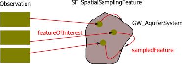
An alternate option is to use a SamplingFeature to hold the locations, each value is serialized in their own Observation.
The following example is a stripped down version, just showing how Observation, SF_SpatialSamplingFeature and a GW_AquiferSystem are articulated.
<?xml version="1.0" encoding="UTF-8"?>
<gml:Bag xmlns:gwml2="http://www.opengis.net/gwml-core/2.0" xmlns:om="http://www.opengis.net/om/2.0" xmlns:xlink="http://www.w3.org/1999/xlink" xmlns:sf="http://www.opengis.net/samplingSpatial/2.0" xmlns:gml="http://www.opengis.net/gml/3.2" xmlns:xsi="http://www.w3.org/2001/XMLSchema-instance" xsi:schemaLocation="http://www.opengis.net/om/2.0 http://schemas.opengis.net/om/2.0/observation.xsd http://www.opengis.net/samplingSpatial/2.0 http://schemas.opengis.net/samplingSpatial/2.0/spatialSamplingFeature.xsd http://www.opengis.net/gwml-core/2.0 http://ngwd-bdnes.cits.nrcan.gc.ca/service/gwml/schemas/gwml2-core.xsd" gml:id="b1">
   <gml:member>
      <om:OM_Observation gml:id="o1">
         <om:phenomenonTime/>
         <om:resultTime/>
         <om:procedure/>
         <om:observedProperty/>
         <om:featureOfInterest>
            <sf:SF_SpatialSamplingFeature>
               <sam:sampledFeature>
                  <gwml2:GW_AquiferSystem gml:id="aquifer">
                  <!-- properties of aquifer system remove for sake of brievity -->
                  </gwml2:GW_AquiferSystem>
               </sam:sampledFeature>
               <sf:shape>
                  <gml:Point srsName="EPSG:4326" gml:id="p1">
                     <gml:pos>64 -112</gml:pos>
                  </gml:Point>
               </sf:shape>
            </sf:SF_SpatialSamplingFeature>
         </om:featureOfInterest>
         <om:result/>
      </om:OM_Observation>
   </gml:member>
   <gml:member>
      <om:OM_Observation gml:id="o2">
         <om:phenomenonTime/>
         <om:resultTime/>
         <om:procedure/>
         <om:observedProperty/>
         <om:featureOfInterest>
         <sf:SF_SpatialSamplingFeature>
         <!-- refers to an already serialised aquifer (above) -->
               <sam:sampledFeature xlink:href="#aquifer" xlink:title="Aquifer x"/>
               <sf:shape>
                  <gml:Point srsName="EPSG:4326" gml:id="p3">
                     <gml:pos>65 -113</gml:pos>
                  </gml:Point>
               </sf:shape>
            </sf:SF_SpatialSamplingFeature>
         </om:featureOfInterest>
         <om:result/>
      </om:OM_Observation>
   </gml:member>
   <gml:member>
      <om:OM_Observation gml:id="o3">
         <om:phenomenonTime/>
         <om:resultTime/>
         <om:procedure/>
         <om:observedProperty/>
         <om:featureOfInterest>
         <sf:SF_SpatialSamplingFeature>
               <sam:sampledFeature xlink:href="#aquifer" xlink:title="Aquifer x"/>
               <sf:shape>
                  <gml:Point srsName="EPSG:4326" gml:id="p3">
                     <gml:pos>65 -112</gml:pos>
                  </gml:Point>
               </sf:shape>
            </sf:SF_SpatialSamplingFeature>
            </om:featureOfInterest>
         <om:result/>
      </om:OM_Observation>
   </gml:member>
</gml:Bag> 

| I | Attachment | Action | Size | Date | Who | Comment |
|---|---|---|---|---|---|---|
| |
many_obs.png | manage | 14 K | 12 Nov 2014 - 18:43 | EricBoisvert | linking many spatially distributed observations |
Edit | Attach | Print version | History: r5 < r4 < r3 < r2 | Backlinks | View wiki text | Edit wiki text | More topic actions
Topic revision: r5 - 08 Dec 2014, EricBoisvert
- Webs
-
 AIP8
AIP8
- ASTROdwg
- AgricultureSummit
- AustraliaNewZealandForum
- AviationDWG
- BigDataDwg
- BusinessValueCommittee
- CATdiscuss
- CDBswg
- CRSdefinitionResolver
- CRSdwg
- CanadaForum
- ChinaForum
- CitSciIE
- CitizenScienceDWG
- ClimateChallenge2009
- CoveragesDWG
- DiscreteGlobalGridSystemsDWG
- EMSpectrumDWG
- EMspectrumDWG
- ERGuidance
- EUforum
- EarthCube
- EnergyUtilitiesDwg
- GML
- GeoSciMLswg
- GeoScienceDWG
- GeocodingAdHoc
- Geospatial3DMS
- HealthDWG
- HydrologyDWG
- I15swg
- ILAFpublic
- ISGdwg
- Ideas4OGC
- JAG
- JSONsubGroup
- JapanAssistance
- LandAdminDWG
- MLSdwg
- Main
- MarineDWG
- MassMarket
- MetOceanDWG
- NREwg
- NetCDFu
- NordicForum
- OGC
- PointCloudDWG
- QualityOfService
- SWEProCitSci
- Sandbox
- SmartCitiesDWG
- System
- TemporalDWG
- UKIAP2013
- UrbanPlanningDWG
- Vocabulary
- WCTileServiceSWG
- WPS
- WaterML
If you enter content here you are agreeing to the OGC privacy policy.
Copyright &© by the contributing authors. All material on this collaboration platform is the property of the contributing authors.
Ideas, requests, problems regarding OGC Public Wiki? Send feedback